|
Area : 280.84 km2 (108.43 sq mi) City population 171,952 (2015) people Density: 612.28/km2 (1,585.8/sq mi) Country: Hungary (+36) - Telecom Zone: Europe (+3 or +4) Elevation: 75 m (246 ft) Area Code +36 62 SZEGED WEATHER |
|
|
| 1) City Pages |
Search by Utilities
 City of Szeged
Tourist Office Public Transport Airport
Search by Hotel
|
|---|
| 2) Yellow Pages |
Search by Activity
Yellow Pages.hu via PBof.com Kozuleti.com via PBof.com more Yellow Pages Golden Pages |
|---|
| 3) White Pages |
Search by Name
Telefon Konyv.hu via PBof.com Linkedin via PBof.com FB.com via PBof.com more White Pages
|
|---|
 |
GPS Coordinates Szeged: Latitude: 46° 15' 18" N Longitude: 20° 8' 42" E Decimal: 46.255°, 20.145° |
|

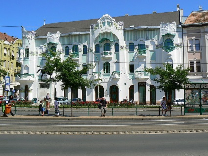 |
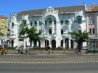
Szeged is the 3rd largest city of Hungary. The city is the third largest city of Hungary, the largest city and regional centre of the Southern Great Plain and the county seat of Csongrad county. The name Szeged might come from an old Hungarian word for corner (szeg), pointing to the turn of the river Tisza that flows through the city. Szeged and its area have been inhabited since ancient times. Ptolemy mentions the oldest known name of the city: Partiscum. It is possible that Attila, King of the Huns had his seat somewhere in this area. The name Szeged was first mentioned in 1183, in a document of King Bela III. Szeged is situated near the southern border of Hungary, just to the south of the mouth of the Maros River, on both banks of the Tisza River, nearly in the centre of the Carpathian Basin. |
|
Phone Book of Szeged: City Directory Yellow Pages and White Pages Pages Jaunes et Pages Blanches Szeged Paginas Amarillas y Paginas Blancas Szeged Gelbe Seiten und Telefonbuch Szeged Pagine Gialle e Pagine Bianche Szeged |
|