|
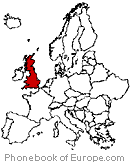
10.6 km² (4.1 miles²) - City population 33,622 people Density: 3,200/ people/km² (8,200/sq mi) Country: Jersey (+385) - Telecom Zone: Europe (+3 or +4) Area Code +44 1534 SAINT HELIER WEATHER |
|
|
| 1) City Pages |
Search by Utilities
 City of St Helier
Tourist Office Public Transport Airport
Search by Hotel
|
|---|
| 2) Yellow Pages |
|---|
| 3) White Pages |
Search by Name
BT Phone Book via PBof & Google Find My Past.co.uk Linked in.com more White Pages
|
|---|
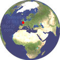 |
GPS Coordinates St Helier: Latitude: 49° 11' 13.2" N Longitude: 2° 6' 25.2" W Decimal: 49.187 -2.107 |
|

 |
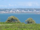
St Helier is one of the twelve parishes of Jersey, the largest of the Channel Islands in the English Channel. An Abbey of St Helier was founded in 1155 on L'Islet, a tidal island adjacent to the Hermitage. The parish is divided into vingtaines for administrative purposes: • La Vingtaine de la Ville • Canton de Bas de la Vingtaine de la Ville • Canton de Haut de la Vingtaine de la Ville • La Vingtaine du Rouge Bouillon • La Vingtaine de Bas du Mont au Pretre • La Vingtaine de Haut du Mont au Pretre • La Vingtaine du Mont a l'Abbe • La Vingtaine du Mont Cochon |
|
Phone Book of St Helier: City Directory Yellow Pages and White Pages Pages Jaunes et Pages Blanches St Helier Paginas Amarillas y Paginas Blancas St Helier Gelbe Seiten und Telefonbuch St Helier Pagine Gialle e Pagine Bianche St Helier |
|