|
45 km² (17 miles²) - City population 272,169 people Density: 10,524/km2 (27,260/sq mi) Metro City population 385,093 people Country: Bangladesh (+88) - Telecom Zone: North Asia (+8) Elevation: 1 m (4 ft) Postal code: 8200 Area Code: +880 431 BARISAL WEATHER |
|
|
| 1) City Pages |
Search by Utilities
 City of Barisal
Tourist Office Public Transport Airport
Search by Hotel
|
|---|
| 2) Yellow Pages |
|---|
| 3) White Pages |
|---|
 |
GPS
Barisal Lat: 22° 48' 0" N Long: 90° 30' 0" E Dec:22.8°, 90.5° |
|

|
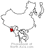
Barisal is the 17th largest city of Bangladesh. Barisal was a semi-independent area in the Mughal period because of heavy fighting between them and Hindu chiefs, the last being Raja Nakuleswar Bose. In course of time, it fell under Bengal Nawabs and British India, later passed to Bangladesh. Barisal District is bouded by Madaripur, Shariatpur, Chandpur and Lakshmipur districts on the north, Patuakhali, Barguna and Jhalokati districts on the south, Bhola and Lakshmipur districts on the east, Jhalokati, Pirojpur and Gopalganj districts on the west. |
Phone Book of Barisal: City Directory Yellow Pages and White Pages Pages Jaunes et Pages Blanches Barisal Paginas Amarillas y Paginas Blancas Barisal Gelbe Seiten und Telefonbuch Barisal Pagine Gialle e Pagine Bianche Barisal |
|
Phonebook of Bangladesh.com
Phonebook of North Asia.com